Geospatial Data Integration with Semantic Web Services: the eMerges Approach
Vlad Tanasescu • Alessio Gugliotta • John Domingue • Leticia Gutiérrez Villarías • Rob Davies • Mary Rowlatt • Marc Richardson • Sandra Stincic
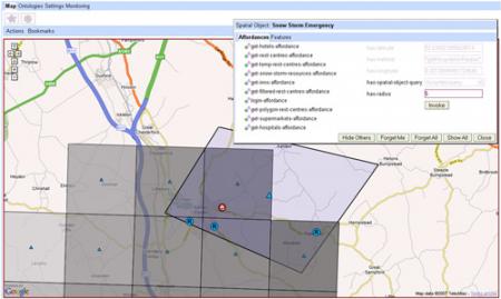
Geographic space still lacks the semantics allowing a unified view of spatial data. Indeed, as a unique but all encompassing domain, it presents specificities that geospatial applications are still unable to handle. Moreover, to be useful, new spatial applications need to match human cognitive abilities of spatial representation and reasoning. In this context, eMerges, an approach to geospatial data integration based on Semantic Web Services (SWS), allows the unified representation and manipulation of heterogeneous spatial data sources. eMerges provides this integration by mediating legacy spatial data sources to high-level spatial ontologies through SWS and by presenting for each object context dependent affordances. This generic approach is applied here in the context of an emergency management use case developed in collaboration with emergency planners of public agencies.
The Geospatial Web ▪ Copyright 2007 Springer ▪ ISBN: 1-84628-826-6
![]()
| Download |