Fire Alerts for the Geospatial Web
Graeme McFerren • Stacey Roos • Andrew Terhorst
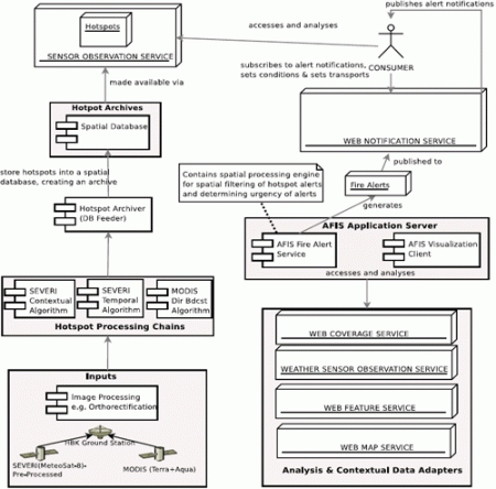
The Advanced Fire Information System (AFIS) is a joint initiative between CSIR and Eskom, the South African electricity utility. AFIS infers fire occurrences from processed, remotely sensed data and triggers alarms to Eskom operators based on the proximity of fire events to Eskom’s infrastructure. We intend on migrating AFIS from a narrowly focussed “black-box” application to one servicing users in multiple fire-related scenarios, enabling rapid development and deployment of new applications through concept-based queries of data and knowledge repositories. Future AFIS versions would supply highly tuned, meaningful and customized fire alerts to users based on an open framework of Geospatial Web services, ontologies and software agents. Other Geospatial Web applications may have to follow a similar path via Web services and standards-based architectures, thereby providing the foundation for the Geospatial Web.
The Geospatial Web ▪ Copyright 2007 Springer ▪ ISBN: 1-84628-826-6
![]()
| Download |