Development, Implementation and Application of the WebGIS `MossMet`
Roland Pesch • Gunther Schmidt • Winfried Schröder • Christian Aden • Lukas Kleppin • Marcel Holy
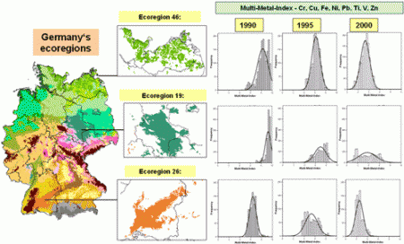
Since 1990, “Heavy Metals in Mosses Surveys” have been performed every five years in at least 21 European countries, including Germany, in order to map spatial and temporal trends of the metal bioaccumulation in terrestrial ecosystems. The monitoring data consist of measurement data on metal loads in ectohydrical mosses as well as site-specific metadata to characterize the sampling locations with regard to, e.g., vegetation, land use and the distance of the sites to emission sources. To optimize the data handling for the moss survey 2005/06, we developed the WebGIS MossMet with the help of open-source components. Thus, the metadata can be integrated with the information system via the Internet by the moss samplers. The WebGIS MossMet comprehensively documents the metadata, the measurement values and statistically derived metal bioaccumulation indices regionalized for ecoregions depicting the landscape coverage of Germany. In the German moss survey 2005/06, the WebGIS MossMet was applied routinely.
The Geospatial Web ▪ Copyright 2007 Springer ▪ ISBN: 1-84628-826-6
![]()
| Download |