A Geospatial Web Platform for Natural Hazard Exposure Assessment in the Insurance Sector
Julien Iris • Jérôme Chemitte • Aldo Napoli
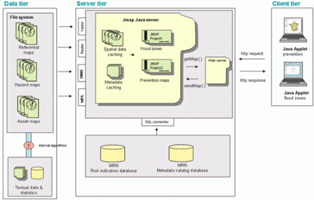
The work of natural hazard exposure assessment involves various geographic data sets (referential, hazard, assets) and various disciplines intended for insurance professionals (catastrophe modeling, prevention engineering). The emergence of Geospatial Web technology induces the emergence of new sets of online services. Mission Risques Naturels (MRN) is a French actor in the mutualization and diffusion of information on natural hazards knowledge and prevention for the general interest of insurance professionals. The MRN Web-GIS platform has been built to address these requirements. This chapter starts by presenting the role of MRN in the network of natural hazard assessment. It then presents Geospatial Web tools for natural hazard exposure assessment as well as the system architecture of the MRN Web-GIS platform, including all its services.
The Geospatial Web ▪ Copyright 2007 Springer ▪ ISBN: 1-84628-826-6
![]()
| Download |